


.png)


Mines, missiles and risky waters: How Indian Navy is secretly guiding ships through Strait of Hormuz
As tensions disrupt shipping through the Strait of Hormuz, the Indian Navy has stepped in with a layered strategy that goes beyond escort operations. From backchannel coordination to real-time navigation support, India is actively helping its merchant fleet cross one of the world’s most volatile maritime chokepoints.
According to sources cited by CNN-News18, the Navy is not only escorting vessels after they exit the strait but is also assisting them in choosing safe routes before and during the transit.
A carefully managed transit through high-risk waters
A typical journey for Indian vessels begins from ports such as Ras Tanura in Saudi Arabia. From there, ships move through the Persian Gulf towards the Strait of Hormuz, a journey that can take up to two days depending on speed and routing decisions.
Given the current security situation, this transit is no longer routine.
Once a vessel is cleared to move, the Indian Navy becomes closely involved. While Indian warships are not deployed inside the Persian Gulf or the Strait of Hormuz, they provide continuous guidance to ships navigating the region.
One key step involves ensuring vessels clearly identify themselves.
Ships are advised to indicate their ‘Indian’ status through AIS, or Automatic Identification System, which helps in recognition and reduces the risk of misidentification in a tense environment.
Escort begins after the strait
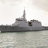
After crossing the Strait of Hormuz, ships enter the Gulf of Oman, where Indian Navy warships take over escort duties. From there, vessels are guided safely into the Arabian Sea.
India has deployed multiple warships in and around the Gulf of Oman and the Arabian Sea to support these operations. These ships have already escorted Indian-flagged LPG tankers such as Pine Gas and Jag Vasant, with visuals of these missions widely circulating online.
According to CNN-News18, the Navy maintains constant communication with vessels throughout the process.
“Officials from the Indian Navy keep in touch with merchant vessels transiting from the Strait of Hormuz. There is a lot of ground assessment and conversations with stakeholders. The Indian Navy assists ships in deciding the safe route and keeps a close watch till the passage is completed," an Indian government official said.
Backchannel diplomacy and on-ground coordination
Behind these operations lies a significant diplomatic effort. Sources told CNN-News18 that India is engaging with regional stakeholders through backchannels to ensure safe passage for its vessels. These conversations play a crucial role in determining when and how ships can attempt transit.
At present, at least five Indian naval ships are deployed in the region. Some are part of ongoing missions, while additional vessels have been sent to strengthen escort capabilities.
Around 20 merchant ships remain stranded due to the volatile situation. Decisions on their movement are being taken based on evolving conditions.
The Navy is also extending humanitarian assistance where required. For ships stuck in the region and facing shortages of food and water, Indian warships are providing essential supplies.
Hidden threats beneath the surface
The dangers in the Strait of Hormuz are not limited to visible threats. Media reports have indicated that US intelligence agencies have flagged the possible presence of underwater mines in the region, allegedly deployed by Iran. These mines can inflict severe damage on vessels, making navigation even more complex.
This is where technical expertise becomes critical.
Why hydrographic charts matter
Shipping in such high-risk waters depends heavily on accurate navigation systems, particularly hydrographic charts.
These charts map the ocean floor, identifying hazards that are not visible on the surface. They are created using specialised survey vessels that scan seabeds and mark safe routes for navigation.
A large number of vessels operating in the Arabian Sea and the wider Indian Ocean rely on hydrographic charts produced by India. This gives the Indian Navy a significant advantage in guiding ships through dangerous zones.
By combining real-time intelligence with detailed seabed mapping, the Navy can help vessels avoid both natural and man-made hazards.
A multi-layered response to a complex crisis
India’s approach reflects a mix of military readiness, technical capability and diplomatic coordination.
While warships provide visible security in safer waters, the more critical work happens behind the scenes through route planning, stakeholder engagement and continuous monitoring.
In a region where risks range from geopolitical tensions to hidden underwater threats, this integrated strategy is helping ensure that Indian vessels can navigate safely through one of the most dangerous maritime corridors in the world.
Source: Moneycontrol
#theshippingtribune #latestnews #shippingnews #dailynews #Maritimenews #shippingindustry #news #media #newsupdate #maritime #shippingnewsworldwide
Related News

Shipping News
Leave Comments


Comments